Its destinations and historical context
Companion text to the Roman road site, created for the AAA (Archaeological Association of the Algarve) and also for "Friends of the Museum", of São Brás de Alportel.
Best thanks to Peter Booker for his careful text review. All current obscurities are my sole responsibility.
Abstract
The slabbed road section at Vale da Serra (Moncarapacho) is of Roman origin and belongs to the inland road that joined Ossonoba and Balsa to Pax Iulia and Emerita. The branches from Ossonoba and Balsa met at Moncarapacho, where the roadway to the North started.
This major public road was integrated in the Antonine Itinerary Item de Esuri Pace Iulia, at the stage Ossonoba-Aranni. The terrain distance, from Ossonoba to Arannis (identified with Santa Bárbara de Padrões), is 60 Roman miles, the same value as in the Roman itinerary.
Moncarapacho was a secondary agglomeration (vicus) of the Balsa territory, a religious centre of regional importance at a main crossroad.
Roman road at Vale da Serra
Copyright Sandra Rodrigues, 2004
Introduction
The area which is known as the Algarve was under Roman domination from the first years of the second century BCE. Roman influence was of much longer duration here than most of Gaul, Germany, Britain or even the greater part of Iberia.
The first 150 years of Roman presence were basically military, due to their long struggle to conquer Iberia and prolonged by the continual Civil Wars of the late Republic. Subjected indigenous political entities could therefore keep their territories and wide formal autonomies, taking sides in the Roman internal wars until the time of Caesar (60-44 BC).
It is only after the defeat of Sextus Pompeius, in 36 BC, that Augustus and Agrippa were able to begin the final colonial "pacification" and "resettlement" of the Iberian shores of the Gulf of Cadiz.
The resulting territorial organization of the Cuneus Ager (The Eastern Cynetum* in Southern Lusitania) established three civitates in the old western Turdetanian lands: Ossonoba, Balsa and Myrtilis.
Cynetum Is a pre-roman latinized choronym, used by Rufus Festus Avienus (IV AD)in his poem Ora Maritima, referring the territory and people of actual Algarve in pre-Roman times (c. VI BC):
inde Cempsis adiacent 200
populi Cynetum. tum Cyneticum iugum,
qua sideralis lucis inclinatio est,
alte tumescens ditis Europae extimum
in beluosi vergit Oceani salum.
Ana amnis illic per Cynetas effluit 205
sulcatque glaebam....hinc dictum ad amnem solis unius via est, 222
genti et Cynetum hic terminus
Translation Afterwards, the Cempsis (people) lay adjacent to the people of the Cynetum.
After, (lays) the Cape Cyneticum, where the sidereal light (the Sun) sets, rising highly as the furthest extremity of rich Europe,where she plunges in the waves of the Ocean inhabited by monsters. The river Ana flows through the Cynetas, furrowing their territory....It is said that from here (the Sacred Promontory) to the (Ana) river there is a journey of a single day;
here is the limit of the Cynetum and its people.
|
Ossonoba and Myrtilis (the actual Faro and Mértola) kept their pre-Roman location with the Augustan revolution. Balsa was moved from Cerro do Cavaco (1 km North of Tavira) to a coastal settlement, founded most probably by Pompey the Great after 67 BC, after the "Pirates War".
The three towns, together with Baesuris (modern Castro Marim which was an old VIIth century BC oppidum at the Anas delta, now downgraded to a vicus of the Balsa territory) became the nodal points of the Roman occupation and its road system.
The natural obstacle to transportation constituted by the Algarvian "Serra" highlights the role of the few existing natural pathways, used and reused since Pre-History to the XIXth century. The most obvious of them all is, of course, the river Anas – Guadiana - and its accompanying road in the right margin of the narrow lower valley.
The inland roads, through the mountains, were also essential for the local economies, tending to gain or lose importance according to the prosperity or decline of the coastal centres and territories to which they were connected.
The longitudinal road parallel to the coast, from Baesuris to the Sacrum Promunturium – Cape Saint Vincent – became, in Roman times, the fundamental communication axis of the Cynetum, connecting the Anas delta to Balsa, Ossonoba, Portus Magnus, Ipses and Laccobriga.
The main archaeological sign of its importance is the Terminus Augustalis and miliary of Bias, the milestone found at "Ribeira das Fontes Santas" (Bias do Sul, Olhão) and nowadays kept in Moncarapacho Museum. Dating from the 1st half of the first century CE, it signals the distance of X roman miles from Ossonoba, in the direction of Balsa, and it defines the border limit between the territories of both towns.
The milestone inscription reads:
[...] AVG(usto) PONT/IFICIM/AXIMO / M(illia) P(assuum) X.Augustus, Pontifex maximus, 10 miles
Milestone of Bias
Copyright Vasco Mantas, 1997
The absence of further known milestones is partially compensated for by the relative abundance of original bits of road pavement (either surviving or recorded), fossil name places and strings of Roman settlements, along reused roads or reconstituted limits of ancient tidal estuaries.
The result allows us to have a convenient working model of the Roman road system of Algarve, integrated in a general geography of the Roman domain.
Roman settlements and roads between Ossonoba and Balsa
The Antonine Itineraries
As in many other parts of the Roman Empire, the ancient document collection known as Antonine Itineraries (AI), dated from the IIIth century CE, provides useful information about the Roman road network and its role in administrative, military and fiscal organisation.
In Algarve, and in the whole of Conventus Pacensis, following the geo-economic evidence and the interpretations of Denis Van Berchen and other investigators, the AI reflects the hierarchy of roads selected by the provincial government for the cursus publicus (official courier and State authority transport) and for the regional collection of the annona tribute, paid in kind, towards the exporting ports or the provincial and conventual capitals.
Three of the known AI crossed the Cynetum:
Salacia – Ossonoba
This itinerary from Alcácer do Sal to Faro is, unhappily truncated, missing all intermediate mansiones (travel stops with accommodations in tax gathering centres). This is not the place to summarise the conjectures about its course but it could eventually pass along an important Roman axis identified by means of archaeological and topographic studies, running though Alvalade, Garvão and Messines.
Baesuris - Pax Iulia (per compendium, by the direct way)
From Castro Marim to Beja, this route corresponds to the direct Guadiana road, passing through Myrtilis; Pax Iulia to Myrtilis by road and Myrtilis to Baesuris both by river and road.
Land transportation was, in average, 7-9 times more expensive than river transportation in Roman times, according to several studies, making rivers favoured inland routes for heavy loads.
Products of the mines from the Anas lower basin and further mining centres (like São Domingos and Vipasca – Aljustrel) were carried to the river over a partially preserved secondary road system. Bulky imported products would also navigate up the river as far as Myrtilis, on their way to Pax Iulia, Emerita and all Southern Lusitania.
Before and after the Romans and until the dawn of the XXth century, the Anas was the only feasible inland approach to the Algarve, in times where road systems were derelict or inexistent. History also shows its strategic value as route of invasion and rear line of military supply.
The fluvial roadSailing (and rowing) on the Anas had limitations (and still has...) due to its strong tides, wind patterns and relatively narrow width.Sailing needs intermediate tide waiting harbours, still functional until quite recently and corresponding to important Roman riverside settlements.A continuous travelling flow also needed a heavy and expensive infrastructure: a waterfront technical road constantly repaired after regular flooding, supporting a boat towing and piloting service and metalled as a quick courier driveway. The disposition of the archaeological river settlements and their connecting waterfront path pinpoints such a Roman infrastructure between the places of Amoreira Velha and Alcoutim.
|
The river was a provincial border, separating Lusitania from Baetica. The right margin belonged to the territory of Balsa. It is the only one to have clear signs of a systematic structure of service roads, riverside stations and technical harbours, creating a line of dense Roman settlement that shows the geo-economic importance of the river.
In the almost deserted left margin (already in Baetica), a bit to the north of modern Alcoutim, was located Praesidium, a mansio of another AI, with a winding and complex course between Emerita and the mouth of the Anas, away from the river margin.
There are concentrated in the areas of Álamo and Vale do Conde very luxurious villas and a temple of unusual dimension, and they most probably correspond to an official centre, associated with traffic control and riverside fiscal administration.
BeasurisThe Iron-age Baesuris oppidum (The actual castle hill of Castro Marim) seems to have been abandoned in the beginning of the Empire, replaced by a string of industrial and port settlements, dispersed around the ancient inner shore or islands of the delta. The whole constituted an important fish preserving production zone, with pottery factories of garum containers and earthenware. Several spots specialized in storage of imported ceramics and other products, or were prosperous residential villae. |
The road measurements both from Balsa and from Myrtilis are consistent with the AI values towards a place some 5 km north of old Baesuris. This mansio would have been therefore located in a Roman settlement nowadays called "Monte dos Castelhanos", a seemingly fortified place on the road, near a harbour in a secondary Anas estuary, nowadays silted up.
Baesuris - Pax IuliaThis third itinerary, also from Castro Marim to Beja, follows an inland course, first to the West by the littoral road to Balsa and Ossonoba and then up North, by the hills, to Arannis and then to Salacia or Sarapia, on the way to Pax Iulia.
In the AI the last stages of this route are notoriously and irremediably interpolated with another route. After Arannis it may probably be mixed up with another itinerary going from Salacia to Arucci.
This is the itinerary that interests us here, in its stage from Ossonoba to Arannis.
From Ossonoba to Arannis
The location of Arannis and the corresponding route from Ossonoba has been matter of discussion since the XIXth century. Arannis was identified with Garvão, but there was reason to doubt this identification, namely that the measured distances either from Salacia or from Ossonoba did not match the AI values.
Garvão
Was an Iron Age Celtic sanctuary in a very small oppidum ("Castelo"), whose well known votive deposit showed an ophthalmological functionality.Its Roman occupation does not seem to go beyond the time of Augustus.The name Garvão, probably derived from the locally documented Arab gentilic Banu Tharouan, has a viable philological evolution from the Celt stem TARVO (bull), and may be hypothetically reconstructed as TARVANNA or *TARVANUM. This name, the absence of Roman Imperial findings and the unmatched distance disqualify Garvão as the location of Arannis, other Celtic contemporary toponym. |
In 1994 a huge votive deposit of Roman lucernae (more than 15 000, from the first to the late third century CE, representing the biggest Portuguese collection) was discovered near the chapel and cemetery of Santa Bárbara de Padrões (Castro Verde).
José Leite de Vasconcelos (1897) had already referred the existence of extensive amounts of opus signinum under the whole village and two sections of a Roman wall of Augustan type. The great late master tells the anecdote that the signinus was so common that the villagers thought it was a natural rock.
Later prospection showed a small Roman dam, large areas with scattered Roman building materials and structures of a Roman sanctuary (a large basin and walls), later integrated in a Paleochristian basilica. Our own topographic survey has detected further urban signs of a
Roman town: strong points of past regularity in street alignments and convergence of pathways, allowing the reconstitution of a hexagonal or octagonal walling system containing a simplified hipodamic street layout around a main decumanus, in the same line as the sanctuary axis.

Urban model of Roman Arannis (Santa Bárbara de Padrões)
Museu da LucernaCastro Verde (Beja) Displays a selection of the lucernae found in the Roman sanctuary of Santa Bárbara de Padrões. The museum organizes temporary exhibitions, dedicated to Classic themes portrayed in lucernae decorations. Has an archive for specialized research. |
This small walled town (with an estimated area of about 13 ha) is at the centre of a mining area of scattered settlement, made up of castella from the time of Augustus, many of which were later replaced by neighbouring rural villae. It was an important regional road network centre, and large portions of unslabbed agger pavement have been identified towards the Algarve, in the area of Caiada.
As we will see below, the measure of the terrain road axis from Santa Bárbara de Padrões to Ossonoba is precisely 60 Roman miles, corresponding to the exact value stated in the AI, giving a strong empiric confirmation to the identification of this significant Roman town with Arannis, a hypothesis already formulated by Manuel Maia in 1987.
It must be referred the great similarity of lucernae types found at the sanctuaries of Faro, Santa Bárbara de Padrões and Peroguarda (Beja), all along our road. This discovery by Maria Maia allowed her to put up the hypotheses that the lucernae (made in Africa, Italy, etc.) were imported to Ossonoba and carried to the inland sanctuaries, accompanying the supplicants some of whom would also be road travellers.
In fact, the oldest road map of Southern Portugal (Alphonse Allard, 1670) shows clearly a road starting in Moncarapacho and crossing the "Serra" towards the area of Santa Bárbara de Padrões. However, in the map of 1762 and in other more recent cartography this road is not represented, therefore showing its downgrade after the XVIIth century.
Road from Moncarapacho to Beja by Santa Catarina and Serra do Caldeirãopassing probably in Santa Bárbara de Padrões (1670)
During archaeological mapping of the extensive "freguesia" of Cachopo (2000), the first Roman sites in association with the course through "Serra do Caldeirão" were identified. The part of the road then surveyed proved to be built over a Pre-Historical natural path, signalled by megaliths and used through the Iron Age until Roman times.
Roman findings in Porto Carvalhoso (coins from a probable burial site) and the discovery in 2005 of a section of slabbed Roman road in a good state of conservation at "Ribeira dos Lagares" (Santa Catarina da Fonte do Bispo) revealed the exact route of this less known part of the road.
Roman road at Ribeiro dos Lagares
The direct interpolation became then obvious: from "Ribeira dos Lagares", through Torre, to the well known Roman road section of "Vale da Serra (Moncarapacho)", orientated towards the "Serra". XIXth century maps still show the old roadway, which disappeared after the building of the new tarmac road between Moncarapacho and Santa Catarina.
The piecemeal reconstitution of the road system between Ossonoba and Balsa together with the large scale reconstitution of the road between Moncarapacho and Santa Bárbara (both published in 2006) allowed the first rigorous measurement of the distance (a first trial had been made in 2002 with insufficient data), producing the following results:
| Route | Distance |
km | m.p.* |
| Ossonoba-Quatrim | By S. Cristóvão and João de Ourém | 11.8 | 8.0 |
Ossonoba-Moncarapacho | By Quatrim | 16.3 | 11.0 |
A |
Ossonoba-Bias (Rib. Fontes Santas) |
By Quatrim and Canada de Bias |
14.8 |
10.0 |
Bias milestone |
|
| 10 |
B | Ossonoba-Santa Bárbara de Padrões | By Moncarapacho, Calçadas de Vale da Serra and Rib. dos Lagares, Porto Carvalhoso, Fronteira, Mealha, Monte da Estrada, S. Pedro de Solis, Caiada, Sete | 88.9 | 60.1 |
Ossonoba-Arannis (Antonine Itinerary) |
|
| 60 |
C | Ossonoba-Balsa | By Bias | 23.8 | 16.1 |
Ossonoba-Balsa | By Moncarapacho | 24.1 | 16.3 |
Ossonoba-BalsaAntonine Itinerary) |
|
| 16 |
| Balsa-Fonte Santa |
| 2.11 | 1.4 |
Balsa-Bias |
| 9.04 | 6.1 |
Balsa-Moncarapacho | By Fonte Santa | 7.80 | 5.2 |
Balsa-Gião (Marco) | By Fonte Santa | 7.20 | 4.9 |
* milia passuum: "a thousand steps". Roman mile of 1479 meters.
The table shows that Moncarapacho is 11 roman miles from Ossonoba, a convenient distance for a road station (mutatio).
It also shows that there were two alternative roads between Ossonoba and Balsa, both fulfilling the 16 miles indicated in the AI. They had a common course from Ossonoba to Quatrim and then split: one went through Moncarapacho; and the other through Bias needing a ferry through the ancient and wide Tronco estuary, nowadays silted up. The roads joined again at the sanctuary of Fonte Santa, in the neighborhood of Balsa.
Quatrim was a four ways crossroad between Ossonoba, Moncarapacho, Balsa and Marim. Its name reflects this situation, deriving most probably from *QUATRIN[I]VM , with the sense of four roads.
The distance from Moncarapacho to Santa Bárbara de Padrões is 49 Roman miles, therefore adding up to 60 Roman miles from Ossonoba, what corresponds to the AI distance.
Finally, the distance indicated in the Bias milestone (10 miles) corresponds to the measured distance, confirming its original location at Ribeira das Fontes Santas
 Roman course from Ossonoba to Arannis
Vale da Serra
The road section of Vale da Serra was first described by the José Fernandes Mascarenhas in 1967.
Much later, in 2004, Sandra Rodrigues "discovered" the same road, even if it was already identified and located in the "Carta Arqueológica de Portugal" of 1995! This author had the merit of being the first to publish a photo of the pavement (above reproduced) and to denounce in the press its later destruction by the "Câmara Municipal de Olhão", still another of the uncountable patrimonial crimes perpetrated by local authorities and State-controlled companies.
A shared road
The North course from "Ribeira dos Lagares" to the crossing of river "Vascão" (the Northern limit of Algarve) coincides with the accepted boundary between the civitates of Balsa and Ossonoba. This and its pied-de-poule start, at mid-distance from both towns, reveal it to be a common frontier road, shared by the two populi .
Its choice by the cursus publicus and later integration in the AI has therefore two weighty justifications:
- It was the shortest carriageable route between both Balsa and Ossonoba and Pax Iulia (and therefore Augusta Emerita).
- As the maintenance of the public road service and of its infrastructures was the responsibility of the local communities through which they passed, a shared road might represent a very substantial economy to the respective municipal finances, specially a mountain road with its heavy support costs.
Its regional economic value as a mining road was equally relevant, connecting the exporting centres on the coast with the gossan rich area of Mealha-Barrigões (silver, gold, copper and iron).
Moncarapacho and its mountain sanctuaries
The referred pied-de-poule road topology highlights its centre at Moncarapacho, defining it as a pivotal road station between Ossonoba, Balsa and the interior of Lusitania. The orientation of its original streets and many other modern cadastral limits are perfectly aligned with the Roman cadastral limites of Balsa, showing that it belonged to the pertica (the centuriated area) of Balsa and therefore to the territory of this town.
Roman road of Monte Figo
Scores of Roman findings in the area of the village or its surroundings (most of them identified by Fernandes Mascarenhas in the decades of 1950 and 1960) show its importance at the time, enhanced by the proximity of two important pre-Roman sanctuaries: "Cerro de São Miguel" and "Cerro da Cabeça".
"Cerro de São Miguel" has been identified by several authors with the arcis summitas Zephyris vocata refered by Avienus (Ora Maritima, 223-4), that is, a mount dedicated to Zephirus/Favonius, the deification of the Western Wind, whose yearly start signalled the beginning of Roman Spring.
It is historically the most important natural maritime daytime beacon of the Gulf of Cadiz. It has a rich ethnographic tradition as a meteorological oracle, with influence as far as Huelva. Locally it has a tradition as a sacred place with archaic "pagan" rituals, barely hidden by the cult of Saint Michael (such as the "miraculous healing earth", banquets in May and September and summit fires lighting).
"São Miguel "or "Monte Figo" also contains a Roman road up to the top or to a sanctuary where a source existed (a "well of singular water", according to a friar's text of the XVIth century, which may be translated from the language of the time as "reputed miraculous or holy without the certification of the Church ").
The road comes from the direction of Moncarapacho and has well-preserved slabbed and stone-cut sections, with curves and pavements adequate for vehicular traffic. Some wheel marks may be visible as well as remains of Roman style side drains. Such an expensive road may be justified by the use of the mountain as a maritime night light beacon, besides its obvious religious role.
"Cerro da Cabeça" has an equally rich archaeological and ethnographic register, whose details are too numerous to fit in here. Its memory as sacred mountain ground is kept alive in a popular "enchanted Moorish " fairy tale. In this tale, a Moorish fairy will appear and make rich to whom will tour around the "Cerro" three times at midnight. This topic of pre-Christian religious symbolism is significantly not a stereotype, as it occurs only once in the whole Algarvian tale corpus which was put together in the beginning of the XXth century.
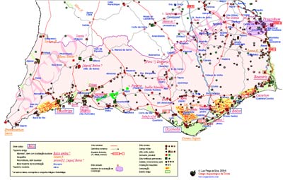
Map of Roman Algarve
Bibliography
Encarnação, José d’1984: Inscrições romanas do Conventus Pacensis, 2 vols., Univ. Coimbra, Coimbra
Fraga da Silva, Luis2002: A região de São Brás de Alportel na Antiguidade, Campo Arqueológico de Tavira, Tavira
2004: Atlas de Balsa, Campo Arqueológico de Tavira, Tavira, http://www.arqueotavira.com/balsa/atlasb/index.html
2006: Calçada romana da Ribeira do Lagar, Campo Arqueológico de Tavira, Tavira, http://arkeotavira.com/arqueologia/via-sc/
2006: Marim Romano, Campo Arqueológico de Tavira, Tavira, http://arqueotavira.com/alg-romano/marim/
2007: Balsa, cidade perdida, Campo Arqueológico de Tavira e Câmara Municipal de Tavira, Tavira
Maia, Manuel1986: Os castella do Sul de Portugal, separata de “Madrider Mitteilungen 27, 1986”, Mainz, 195-223+lâmin. 20-21
1987: Romanização do território hoje português a Sul do Tejo: Contribuição para a análise do processo de assimilação e interacção sócio-cultural 218-14 d.C., 3 vols., policopiado, Lisboa
2006: "De Baesuris a Pax Iulia por Arannis" in Actas das I Jornadas "as vias do Algarve da Época Romana à Actualidade", C. M. S. B. de A., S.Brás de Alportel, pp. 39-45
Maia, Maria e Maia, Manuel1996: Os Castella do Sul de Portugal e a mineração da prata nos primórdios do Império, in “Mineração no Baixo Alentejo”, C.M. Castro Verde, Castro Verde, 60-81
1997: Lucernas de Santa Bárbara, Cortiçol, Castro Verde
Maia, Maria; Maia, Manuel e Silva, Luis Fraga da2007: Vias de Penetração Terrestres entre o Sotavento Algarvio e a Região de Beja da Proto-História à Idade Moderna in “Actas das IIIas Jornadas/Congresso da revista ‘Arquivo de Beja’ (2000)", Arquivo de Beja, Beja.
Maia, Maria e Silva, Luis Fraga da2000: Levantamento da carta arqueológica de Cachopo, Campo Arqueológico de Tavira, Tavira
Mantas, Vasco Gil1997: Os caminhos da serra e do mar in “Noventa séculos entre a Serra e o Mar”, I.P.P.A.R., Lisboa, 311-326
Marques, Teresa (Coord.)1995: Carta arqueológica de Portugal (Algarve-Sotavento), I.P.P.A.A., Lisboa
Mascarenhas, José Fernandes
1967 : "De Ossónoba a Balsa", in Elementos de arqueologia sobre o Algarve, Tavira 1967, 7-25
1967: "Vestígios romanos no ribeiro do Vale da Serra", in Elementos de arqueologia sobre o Algarve, Tavira 1967, pp.32-33
Rodrigues, Sandra2004: As vias romanas do Algarve, CCRA, FaroVasconcelos, José Leite de
1927: De terra em terra. Excursões arqueológico-etnográficas através de Portugal (Norte, Centro e Sul), 2 vols., Imprensa Nacional, Lisboa
 Tavira - Planta de Sande Vasconcelos (1800)
 Reconstituição de Tavira Quinhentista. Montagem baseada em plantas parciais de (Lamas e Duarte, 1985)
 Detalhe da Planta de Tavira, de Leonardo di Ferrari
 Detalhe da Planta de Tavira, de Leonardo di Ferrari
 Detalhe da planta de reconstituição da forma urbana de Tavira em meados do séc. XVI.